IGCSE Theme 4-Map Skills Geography Past Paper questions
Answers 👉 https://jasminejabasingh.blogspot.com/2021/04/igcse-theme-4-map-skills-geography-past_17.html
1. Study the map extract for Voss, Norway. The scale is 1:25 000.
(a) Fig. 1 shows some of the features of the main settlement of Voss. Study Fig. 1 and the map extract, and answer the questions below.
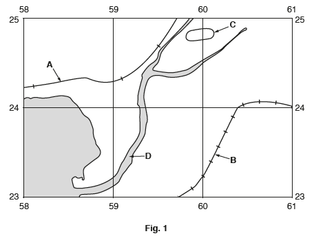
Using the map extract, identify the following features shown on Fig. 1:
(i) feature A; .........................................................................................................................................[1]
(ii) feature B; ........................................................................................................................................[1]
(iii) feature C; .......................................................................................................................................[1]
(iv) the name of the river at D. .............................................................................................................[1]
(b) Describe the site of the settlement at Voss.
...................................................................................................................................................................................................................................................................................................................................................................................................................................................................................................................................................................................................................................................................................[4]
(c) Describe the relief of the area around Sonvesåsen in the south east of the map extract.
...................................................................................................................................................................................................................................................................................................................................................................................................................................................................................................................................................................................................................................................................................[4]
(d) Fig. 2 is a cross section along northing 26 from 580260 to 610260.

Identify:
(i) the land use at X; ...............................................................................................................................[1]
(ii) the land use at Y; ...............................................................................................................................[1]
(iii) the feature at Z. ................................................................................................................................[1]
(e) Fig. 3 shows the road from the southern edge of the map at 593210 to the road junction at point X at 584223.

(i) What is the distance along the road? Circle one correct answer below.
750 metres 1550 metres 2050 metres 3050 metres [1]
(ii) Describe the route of the road from the southern edge of the map to the road junction at X.
......................................................................................................................................................................................................................................................................................................................................................................................................................................................................................................................................................................................................................................................[4] [Total: 20 marks]
2. Study the map extract for Kivik, Sweden. The scale is 1:50 000.
Fig. 1.1 shows some of the features in the south west of the map extract around the settlement of Olof.

(a) Using the map extract, identify the following features shown on Fig. 1.1:
(i) feature A .............................................................................................................................................[1]
(ii) the type of road at B ..........................................................................................................................[1]
(iii) feature C ...........................................................................................................................................[1]
(iv) the height above sea level at spot height D ........................................ metres [1]
(v) the land use in area E ........................................................................................................................[1]
(vi) the land use in area F. ......................................................................................................................[1]
(b) Look at the coastal area from Kivik to the northern edge of the map extract. Give two pieces of map evidence which suggests that this area has a tourist industry.
1...................................................................................
2...................................................................................
[2]
(c) Fig. 1.2 is a cross section along northing 69 from 490690 to the sea at 560690.

(i) Identify feature X. .............................................................................................................................[1]
(ii) Name the settlement at Y. .................................................................................................................[1]
(iii) Using the map, complete the cross section on Fig. 1.2 between Z and the coastline. [1]
(d) Look at the settlements of Olof and S Mellby. Find the churches in Olof and S Mellby, shown
by this symbol: 十
(i) Measure the distance in a straight line between the church at Olof and the church at S Mellby. Give your answer in metres. ....................................... metres [1]
(ii) Give the compass direction from the church at Olof to the church at S Mellby. ............................. [1]
(iii) Measure the bearing from the church at Olof to the church at S Mellby. .......................... degrees [1]
(iv) What is the six-figure grid reference of the church at S Mellby? Tick one box below.

(e)Fig. 1.3 shows an area in the north of the map extract.

Describe the relief of this area.
...................................................................................................................................................................................................................................................................................................................................................................................................................................................................................................................................................................................................................................................................[4][Total: 20]

Comments
Post a Comment